
ESA Missions for Climate
Major ESA satellite missions for monitoring climate change from space
Earth observation satellites carry a wide variety of instruments using both passive and active sensing techniques. These sensors detect radiation in different parts of the electromagnetic spectrum, depending on the sensor type.
The ESA Climate Change Initiative is unique in merging data from different sensors, on missions flown by different space agencies, to generate climate data records with the longest possible time spans. Here are some of the major ESA missions used to construct long-term records of Essential Climate Variables.
ERS | ENVISAT | CryoSat | SMOS | Sentinel-1 | Sentinel-2 | Sentinel-3 | Sentinel-5P | Future missions for climate
ERS mission
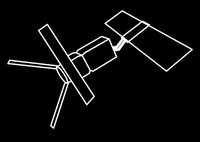
Over nearly 2 decades of operation the European Remote Sensing satellite ERS mission provided a wealth of valuable information for tracking changes in sea level, sea state, sea surface temperature, sea ice thickness, the elevation and velocity of ice sheets, land surface temperature, soil moisture, cloud, aerosol and more.
The ERS-1 mission operated 1991-1999 and was ESA’s first sun-synchronous polar orbiting mission. It carried a newly developed instrument called a Synthetic Aperture Radar (SAR): an imaging radar capable of producing high quality images irrespective of cloud coverage or whether it is day or night. It also carried a radar altimeter for measuring surface height, including wave height and wind speed, and an infrared imaging sensor called a radiometer. ERS-2 operated 1995-2011 with the same comprehensive payload, plus an additional sensor for measuring ozone levels in the atmosphere.
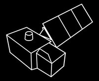
ENVISAT
ESA's ENVISAT (ENVIronmental SATellite) succeeded ERS to provide continuity of measurements as well as advanced instruments for monitoring atmospheric gases and ocean biology. Operating 2002-2012, it carried ten instruments, including the SCIAMACHY spectrometer to detect trace gases in the atmosphere as well as clouds and aerosol. These data contribute to long-term records of ozone, carbon dioxide, methane and water vapour. Data from the GOMOS occultation spectrometer contribute to long-term records of aerosol, ozone, water vapour. ENVISAT's MERIS sensor, a multi-spectral radiometer, contributes to CCI data records for aerosol, cloud, land cover, ocean colour, and water vapour.
CryoSat

CryoSat is an ESA Earth Explorer mission to the ice-covered parts of the planet. Launched in 2010 and still supplying data, it carries the SIRAL instrument - a sophisticated radar altimeter designed to measure the elevation of the ice sheets and marine ice cover. As well as ice thickness, SIRAL data are used for long-term records of sea level and wave height.
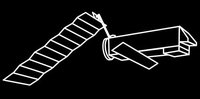
SMOS

The Soil Moisture and Ocean Salinity mission is an ESA Earth Explorer mission that launched in 2009. It has a microwave imaging radiometer (L-band) called MIRAS used in CCI climate data records for soil moisture and ocean salinity.
Sentinel-1

Sentinel-1 is the first of the Sentinel family of satellites launched in 2014 under the European Union’s Copernicus Programme, coordinated by the European Commission in partnership with ESA, EU Member States and other EU Agencies. It is a radar mission aimed at land and ocean monitoring. Sentinel-1 carries a C-band Synthetic Aperture Radar that provides medium and high resolution imaging down to 5m in all weather conditions, day or night. Its data are useful for tracking forest cover, and are used to construct CCI's global maps of above ground biomass, which quantifies the amount of carbon stored in vegetation. Using a technique called InSAR, images from Sentinel-1 can also be used to decipher changes in surface topology to determine surface movement and generate maps of ice sheet velocity and glacier grounding line locations.
Sentinel-2
The Copernicus Sentinel-2 mission systematically acquires images at high spatial resolution - down to 10m resolution - over land and coastal waters, at multiple wavelengths. Launched in 2015, its imagery are used to construct Essential Climate Variables of glacier ice velocity, fire burned area, and maps of land cover.
Sentinel-3

Sentinel-3 is a Copernicus mission launched in 2016 carrying multiple sensors aimed at observing ocean properties and behaviour. It is intended as a mission to provide continuity of data comparable to ENVISAT and CryoSat capability, and its data are used in climate data records of ocean colour, land cover and water vapour (from the OLCI imaging spectrometer), sea and land surface temperature (SLSTR radiometer) and sea level (SRAL radar altimeter).
Sentinel-5P
Sentinel-5P - known as Sentinel-5 Precursor - is the forerunner to the Sentinel-5 Copernicus mission dedicated to air quality and climate. It was launched in 2017 and carries the TROPOMI sensor, the most advanced multispectral imaging spectrometer to date. It observes sunlight that is scattered back to space by Earth’s surface and atmosphere, detecting the unique fingerprints of gases in different parts of the spectrum. A wide range of pollutants such as nitrogen dioxide, ozone, formaldehyde, sulphur dioxide, methane and carbon monoxide can be imaged more accurately than ever before. Data from Sentinel-5P are used to construct the CCI climate data record of global methane concentrations.
Future missions for climate
To meet future data needs, ESA is building new Earth Explorer satellites, and a new wave of Sentinel satellites under the EU's Copernicus programme.
Upcoming Earth Explorer missions:
- EarthCARE: Atmospheric Lidar (ATLID) for aerosols and thin clouds; and a Cloud Profiling Radar (CPR) providing information about thicker clouds & to observe vertical velocities of cloud particles.
- Biomass: A P-band SAR to determine the amount of biomass and carbon stored in forests.
- FLEX: An imaging spectrometer in the red-near infrared to pick out plant fluorescence.
- FORUM: A mission to monitor far-infrared radiation at the top of the atmosphere to determine the strength of the greenhouse effect, crucial for climate modelling.
Upcoming Copernicus Sentinel missions:
- Sentinel-6/JASON-CS mission: ESA is developing the next-generation Poseidon altimeter for topographic measurements of oceans, coasts and inland water, due to launch in November 2020.
Copernicus high priority candidate missions:
- CO2M: a relatively high spatial-resolution imaging spectrometer to track individual sources of CO2, and discriminate between anthropogenic and natural sources of the gas.
- CHIME: A hyperspectral imager to return detailed information on the health of plants, coastal mapping and land-cover mapping.
- LSTM: A thermal infrared radiometer to measure land-surface temperature and rates of evapotranspiration in unprecedented detail.
- CRISTAL: An altimeter to measure the height of Earth's ice fields - it will map sea-ice thickness and snow depth, as well as ice elevation on land.
- ROSE-L: An L-band radar to observe ice but many other targets as well, including forests, different crop types, and soils.
- CIMR: A microwave radiometer to measure sea-surface temperature, salinity, and sea-ice concentration.